Geography and natural history
“The south Wales Valleys support a treasure trove of biodiversity. Like all good treasure troves it had been lost and long forgotten and has only now been re-found, and like some giant archaeological dig, one discovery has led to another; one find has spurred on the finding of the next.”
Rhigos lies at the apex of the Cynon Valley and the Vale of Neath. Craig y Llyn, the mountain summit above it, is the highest peak in the traditional county of Glamorgan. A glacial cirque excavated into the Pennant Sandstone scarp of Craig y Llyn holds the glacial lake of Llyn Fawr. The glaciers sculpted and over-deepened the valleys into characteristic U-shaped profiles. All the deposits of the Welsh ice were locally derived.
Certain parts of the local landscape surrounding Rhigos have been designated as Sites of Special Scientific Interest including the wooded gorges of Waterfall Country, Cwm Cadlan and nearby Blaencynon SAC. The Joint Nature Conservation Committee which advises the government and devolved administrations on UK-wide and international nature conservation, states that the damp grassland and heath of the Blaencynon site has been noted as an area that supports the marsh fritillary butterfly. This butterfly is threatened not only in the UK, but across Europe. which makes this area of importance in an international conservation effort.
Llyn Fawr
Llyn Fawr (‘large lake’ in Welsh) is a reservoir that occupies one of a series glacial cirques that form the northern escarpment of the South Wales Coalfield uplands, overlooking the heads of the Vale of Neath and the Cynon Valley, South Wales. It is known as the site of an important hoard of weapons and tools from the late Bronze Age and early Iron Age.
It lies on the northern flanks of Craig-y-Llyn, a mountain that is designated as a Site of Special Scientific Interest. The western cirque contains Llyn Fach (‘small lake’). While in government terms, it falls in the unitary authority of Rhondda Cynon Taf, in geographic terms it is actually in the Vale of Neath and its excess waters (all its water before conversion) flow into Nant Gwrelych, which flows into the River Neath at Pont Walby near Glynneath. Less than 1 km to the southeast and south lie the headwaters of the Rhondda Fawr and Rhondda Fach rivers, while 1.5 km to the southwest lie the headwaters of River Corrwg.
Drinking water reservoir
Owing to its rapid and massive industrialisation during its coalfield boom (population increasing from 951 in 1851 to 113,735 in 1901), the Rhondda Valley, which lies on the south side of the escarpment, surpassed the supply of water it could source from its own river, so in 1909 the Water Works division of Rhondda Urban District Council contracted builders to convert Llyn Fawr into a reservoir. Originally having an area of 11.927 acres (0.048 km2), the lake was expanded, by the construction of a 25-foot high embankment dam and deepening of lake bed, to give a total storage volume of 200,000,000 gallons (909 megalitres). With work completed in 1913 giving the new lake a surface area of 21.616 acres (0.087 km2), which then was increased again to 24.75 acres (0.100 km2) sometime before 1970s. The raw water supply then being pumped through a 1.25-mile long tunnel under Craig-y-Llyn to Ty’n-y-waun water treatment works, in Tynewydd, Rhondda. This tunnel is still a critical part of Welsh Water’s infrastructure, supplying the majority of the water supply for the Rhondda valley. Although it is subsiding due to collapsing coal working below, with water now pooling in the middle, investigation is being made into either ways to stabilise it or replace it.
Bronze age hoard
It was during the deepening of the lake that the Llyn Fawr Hoard was discovered between 1909 and 1912. It contains many objects from the late Bronze Age, but also a number of iron objects, notably an iron sword of the Hallstatt type. Two other iron implements were found – a spear and a socketed sickle. Bronze items included two cauldrons and axeheads. The items appear to have been placed in the lake as votive offerings. The date of these items is uncertain because of the context of the finds, but the sword is thought to date from about 650 BC. It is the earliest iron object to have been discovered in Wales. The hoard gave its name to the Llyn Fawr Phase, which is the last phase of the Bronze Age in Britain. The hoard is now in the possession of Amgueddfa Cymru – Museum Wales.
Tower Colliery
Tower Colliery (Welsh: Glofa’r Tŵr) was the oldest continuously working deep-coal mine in the United Kingdom, and possibly the world, until its closure in 2008. It was the last mine of its kind to remain in the South Wales Valleys. It was located near the villages of Hirwaun and Rhigos, north of the town of Aberdare in the Cynon Valley of South Wales.
British Coal closure
After the 1984-5 UK miners’ strike, the Conservative government authorised British Coal to close the majority of the UK’s deep mines on economic grounds, nominally including Tower. But from 30 June 1986, with new underground roads having been driven, all coal from Mardy Colliery was also raised at Tower,[2] the two mines effectively working as one coalfield system. Mardy closed as an access shaft on 21 December 1990.
In October 1993 the red flag was raised on Hirwaun common as a symbol of unity between workers of Tower Colliery during a march to commemorate the Merthyr Rising in 1831, and highlight the plight of their own pit. In 1994, the constituency MP, Ann Clwyd staged a sit-in in the mine to protest against its closure, accompanied by the late Glyndwr ‘Glyn’ Roberts (Senior) of Penywaun.
British Coal closed Tower Colliery on 22 April 1994, on the grounds that it would be uneconomic in current market conditions to continue production.
Colliery buy-out by workers
Led by local NUM Branch Secretary Tyrone O’Sullivan, 239 miners joined TEBO (Tower Employees Buy-Out), with each pledging £8,000 from their redundancy payouts to buy back Tower. Against stiff central government resistance to the possibility of reopening the mine as a coal production unit, a price of £2 million was eventually agreed.
With their bid accepted, the miners marched back to the pit on 2 January 1995, with a balloon inflated for each worker. On 3 January 1995 the Colliery re-opened under the ownership of the workforce buy out company Goitre Tower Anthracite. Philip Weekes, the renowned Welsh mining engineer, was a key advisor to the buy-out team and became (unpaid) Chairman.
In 2014, John Redwood, the Secretary of State for Wales in 1995, and also Director of Margaret Thatcher’s Number 10 Policy Unit 1983–1985, wrote of the period of pit closures and Tower Colliery:
“At the end of the dispute I tried to get the government to offer the miners the right to work a pit the Coal Board claimed was uneconomic for themselves, as I was suspicious about some of the pits the Coal Board wished to close. I wanted a magnanimous aftermath. John Moore the privatisation Minister worked up some proposals but they got into the press before they were fully thought through or cleared with the PM, so the whole idea was lost. It was not until I was in the Cabinet myself that I was able to help one group of miners do just that, at Tower Colliery. They demonstrated that free of Coal Board control it was possible, at least in their case, to run the pit for longer”
Tower regeneration
The management announced at closure that one of the possibilities of creating additional short term value was through open cast mining extraction of the residual 6 million tonnes of anthracite. In August 2010, the company filed a planning application for the extraction by open cast mining of coal to a depth of 165 metres (541 ft), on a 200 acres (81 ha) section of the former coal washery site. Coal would then be transported to Aberthaw Power Station by train.
In 2012 Tower Regeneration Ltd, a joint venture partnership between Tower Colliery Ltd and Hargreaves Services plc was formed. The partnership company received planning permission that year to allow opencast coal extraction on what were termed the surface workings of the former colliery site, on the pre-condition that the site would be subject to land remediation and reclamation, followed by land restoration of the entire Tower Colliery site. The land reclamation works includes: removal of structures; removal of residual contamination; re-profiling of colliery spoil tips; removal of coal workings and mine entries; and provision of surface drainage. The project will create a sloping landform to reproduce semi-natural habitats on the site, and hence prepare the area ground for future mixed-use development.
Hirwaun Industrial Estate
During the Second World War, those not within the colliery industry, and hence in reserved employment, could find similar work at ROF Hirwaun, which was actually sited within Rhigos parish where the present day Industrial Estate is located. Developed by Royal Ordnance Factory and the Ministry of War from 1942 as an offshoot of ROF Newport, it was an engineering ROF producing .303 cartridge cases for Lee–Enfield rifles, and 9mm cartridge cases, which were then shipped to be filled at a Filling ROF. Having built three new roads and associated bungalows to house the workers, all raw materials were shipped in via the former Vale of Neath Railway by the Great Western Railway, using the sidings of the former Tir Herbert brickworks. Day-workers would alight at Rhigos railway station, beyond which were built additional sidings to house the railway carriages that were shipping workers to the site from all over the South Wales valleys. The site of the ROF was discovered by the German military, who ordered a single air raid by the Nazi Luftwaffe in 1943.
At the end of the war, the site was abandoned, and the factory was only demolished in the late 1960s. A range of other businesses then took over the Industrial Estate and further details about these can be found in the W.W Price Collection at Aberdare Library.
Transport
In 1850 the Vale of Neath Railway opened its line between Neath and Aberdare via Hirwaun, completing its mainline to Merthyr Tydfil from Hirwaun in 1853. Rhigos Halt consisted of two platforms and was sited at the north end of the 520 yard long Pencaedrain Tunnel. Brown’s engineering sidings were additionally built to house permanent way vehicles that were maintaining the railway tracks. The climb from Glynneath to Rhigos involved the steep Glynneath embankment, which required all north-bound trains to take on a banker locomotive at Glynneath station, which was released at Rhigos.
After the railway was closed under the Beeching Axe, the council took the opportunity to provide a better road link between Hirwaun and Glynneath, and so bypassed the old Aberdare road by building an extension to A465 road which used most of the trackbed of the abandoned railway. The road has now been identified by the government as being in need of improvement due to restricted traffic flow and poor visibility. The current plans in place are stated by the government to be completed by 2024.
‘The Parrish Road’ was another access to the village which was closed when Celtic Energy opened a controversial opencast mine between Rhigos and Cwmgwrach in 1997. The promise was made to reinstate the road after the mine closed, and talks have been held between residents, Celtic Energy and Neath Port Talbot County Council during 2020.
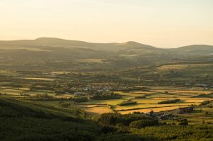 Rhigos (/rˈiɡɒs/) is a small village on the saddle of higher ground between the Vale of Neath and the Cynon Valley. The village developed in the Industrial Revolution through the mineral industry, extracting coal, iron ore and limestone. It was part of the old Neath Rural district Council under Glamorgan until 1974. The village then came under the jurisdiction of The Cynon Valley Borough which subsequently became Rhondda Cynon Taf, South Wales in 1996. It lies just off the old Aberdare road that was the main link between Aberdare and Glynneath, before the A465 road was extended in the 1960s. The hamlets of Cefn Rhigos and Cwm-Hwnt lie to the west of the main village.
The population of the community in the 2011 census was noted as 894. For postal purposes it comes under the town of Aberdare, although it is some 7 miles (11 km) from Aberdare town centre, and 2 miles (3.2 km) from Glynneath. It was noted as a township in the parish of Ystradyfodwg in several historical references and people moved to this rural area to work in local industries. Today, the village is a quiet place to live with views of the Brecon Beacons National Park to the north and is within walking distance of Waterfall Country.
Rhigos (/rˈiɡɒs/) is a small village on the saddle of higher ground between the Vale of Neath and the Cynon Valley. The village developed in the Industrial Revolution through the mineral industry, extracting coal, iron ore and limestone. It was part of the old Neath Rural district Council under Glamorgan until 1974. The village then came under the jurisdiction of The Cynon Valley Borough which subsequently became Rhondda Cynon Taf, South Wales in 1996. It lies just off the old Aberdare road that was the main link between Aberdare and Glynneath, before the A465 road was extended in the 1960s. The hamlets of Cefn Rhigos and Cwm-Hwnt lie to the west of the main village.
The population of the community in the 2011 census was noted as 894. For postal purposes it comes under the town of Aberdare, although it is some 7 miles (11 km) from Aberdare town centre, and 2 miles (3.2 km) from Glynneath. It was noted as a township in the parish of Ystradyfodwg in several historical references and people moved to this rural area to work in local industries. Today, the village is a quiet place to live with views of the Brecon Beacons National Park to the north and is within walking distance of Waterfall Country. 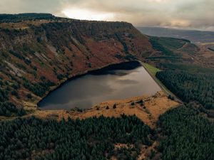
 Originally farmland until the late 1700s, the village developed in the Industrial Revolution through the mineral industry, extracting coal, iron ore and limestone. What is believed to be the first coke fired furnace was built on nearby land by John Mayberry of Brecon in 1757. It came into the possession of the Crawshay family in 1819, which provided much employment until the early 1830s. Francis Crawshay famously built a folly on nearby land and was apparently the only member of the family to speak Welsh. The site was then taken over by the Gloucester Railway Carriage and Wagon Company which ran until the 1930s.
British Rhondda Colliery, later called “The Pandy” and finally Rhigos Colliery was opened during the 1920s. This was a drift mine, and it closed in 1965. Coal was extracted from land near Rhigos in 1864 from a drift mine called Tower Graig. This mine is noted to have been discontinued, but there are records that 420 men were employed by The Marquess of Bute to extract coal from Tower Colliery around the 1890s. The Tower Colliery and was famously the subject of a worker’s buy-out closed in 2008 and its closure saw the last of the deep mines in Wales come to an end. However, Tyrone O’Sullivan who was part of the worker buy out, spoke about the possibility of the land being regenerated in the future. Indeed, in 2019 RCT Council announced that planning had been unanimously granted for Zipline Cymru to construct of a new line at the Tower site which will be the focus for the development of tourism in the area.
Originally farmland until the late 1700s, the village developed in the Industrial Revolution through the mineral industry, extracting coal, iron ore and limestone. What is believed to be the first coke fired furnace was built on nearby land by John Mayberry of Brecon in 1757. It came into the possession of the Crawshay family in 1819, which provided much employment until the early 1830s. Francis Crawshay famously built a folly on nearby land and was apparently the only member of the family to speak Welsh. The site was then taken over by the Gloucester Railway Carriage and Wagon Company which ran until the 1930s.
British Rhondda Colliery, later called “The Pandy” and finally Rhigos Colliery was opened during the 1920s. This was a drift mine, and it closed in 1965. Coal was extracted from land near Rhigos in 1864 from a drift mine called Tower Graig. This mine is noted to have been discontinued, but there are records that 420 men were employed by The Marquess of Bute to extract coal from Tower Colliery around the 1890s. The Tower Colliery and was famously the subject of a worker’s buy-out closed in 2008 and its closure saw the last of the deep mines in Wales come to an end. However, Tyrone O’Sullivan who was part of the worker buy out, spoke about the possibility of the land being regenerated in the future. Indeed, in 2019 RCT Council announced that planning had been unanimously granted for Zipline Cymru to construct of a new line at the Tower site which will be the focus for the development of tourism in the area. 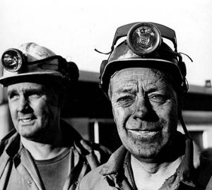 With coal located so close to the surface, it was known by locals to be possible to drift mine coal from Hirwaun common. This activity increased from 1805, until in 1864 the first drift named Tower was started, named after the nearby Crawshay’s Tower, a folly built in 1848 and named after Richard Crawshay.In 1941, a new shaft was sunk to a depth of 160 metres. From 1943 until closure, this shaft was used as the main “return” ventilation shaft and for the transport of men. In 1958 Tower No. 3 was driven to meet the No. 4 colliery workings, and was used as the main “intake” airway, conveying coal to the surface and transporting materials into the mine working areas.The Aberdare branch of the Merthyr line continued north from Aberdare railway station to the colliery. While passenger services terminate in Aberdare, freight services operated several times a day along this stretch of line, directly owned by the colliery.
 Following the closure of Tower Colliery in 2008, the site has been transformed into a major adventure destination known as Zip World Tower. Opened on the historic colliery grounds, Zip World Tower celebrates the industrial heritage of the site while offering thrilling activities for visitors. One of the main attractions is Phoenix, the world’s fastest seated zip line, which provides breathtaking views from the summit of Rhigos Mountain. Additionally, the Tower Climber adventure course, with its 55 obstacles and three-story high structure, offers a challenging experience for adventure enthusiasts. This revitalization project not only preserves the legacy of the colliery but also brings new life and tourism to the area, contributing to the local economy and community engagement